CameraPosition.Buildertarget(LatLng location)zoom(float zoom)bearing(float bearing)tilt(float tilt)map.AnimateCamera(CameraUpdate.newCameraPosition(cameraPosition),durationInMs,callback);
GoogleMapOptions options = new GoogleMapOptions().liteMode(true);
<fragment xmlns:android="http://schemas.android.com/apk/res/android"
    xmlns:map="http://schemas.android.com/apk/res-auto"
    android:name="com.google.android.gms.maps.MapFragment"
    android:id="@+id/map"
    android:layout_width="match_parent"
    android:layout_height="match_parent"
    map:liteMode="true"/>
var marker = new google.maps.Marker({ // Supply map and position params as usual. label: 'A'});
var beachIcon = { url: 'images/beachflag.png', labelOrigin: new google.maps.Point(9, 9)};var marker = new google.maps.Marker({ // Supply the map and position parameters as usual. icon: beachIcon, label: { text: '2', color: 'purple' }});
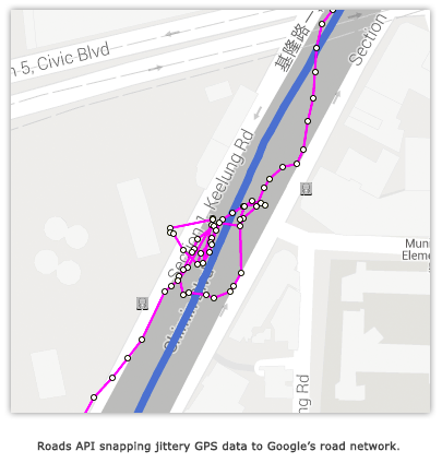
Give us feedback in our Product Forums.