Maps Platform
Product updates, customer stories, and tips and tricks on Google Maps Platform
A sizzling open source release for the Australian Election site
Tuesday, September 27, 2016
One of the best parts of my job at Google is 20 percent time. While I was hired to help developers use Google’s APIs, I value the time I'm afforded to be a student myself—to learn new technologies and solve real-world problems. A few weeks prior to the recent Australian election an opportunity presented itself. A small team in Sydney set their sights on helping the 15 million voters stay informed of how to participate, track real-time results, and (of course) find the closest election sausage sizzle!
Our team of designers, engineers and product managers didn't have an immediate sense of how to attack the problem. What we did have was the power of Google’s APIs, programming languages, and Cloud hosting with Firebase and Google Cloud Platform.
The result is a mish-mash of some technologies we'd been wanting to learn more about. We're open sourcing the
ausvotes.withgoogle.com
repository to give developers a sense of what happens when you get a handful of engineers in a room with a clear goal and a immovable deadline.
The
Election AU 2016 repository
uses:
Go
from Google App Engine instances to serve the appropriate level of detail for users' viewport queries from memory at very low latency, and
Dart
to render the live result maps on top of Google Maps JavaScript API using Firebase real time database updates.
A product is only as good as the attention and usage is receives. Our team was really happy with the results of our work:
406,000 people used our maps, including 217,000 on election day.
We had 139 stories in the media.
Our map was also embedded in major news websites, such as
Sky News
.
Complete setup and installation instructions are available in the
Github README
.
Posted by Brett Morgan, Developer Programs Engineer
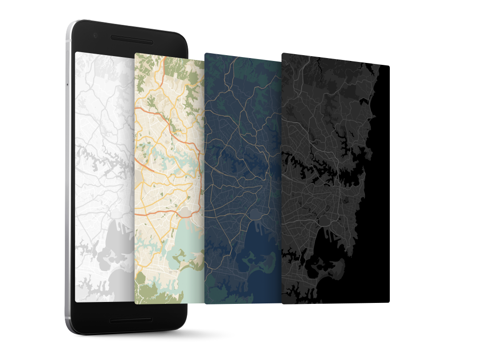
Custom map styling with the Google Maps APIs on Android and iOS
Wednesday, September 21, 2016
Your app, your map style. For iOS and Android.
Cross-platform custom map styling is here—change the color palette of your maps, hide labels, vary road density and toggle points of interest. Your maps can now match your brand and style across your website and your apps!
The Google Maps APIs now support you in creating beautiful styled maps for your Android and iOS apps as well as your website using the same JSON style object.
Easily create your style
The new
Google Maps APIs Styling Wizard
helps you to create a map style in a few clicks. Use one of our pre-built styles or create your own style from scratch.
Access advanced options for further control over every available aspect of your map style including visibility, fills & stroke weight.
Use the styling wizard for point and click custom style creation.
Show what’s important, hide the rest
Custom map styling provides you with ways to tailor your map for a particular use case. Got your own transit stops and want to turn the Google ones off? We’ve got you covered. Want to hide highways and highlight water features? Done. You can control the visibility of labels, landscapes, transit icons, points of interest, roads and more to create the look that reflects your brand and purpose. See the samples for
Android
,
iOS
and
JavaScript
.
Both the iOS and the Android SDKs now support business points of interest as well; this means you’ll now see hotels, restaurants and shops on your maps. They’ll only be visible when you compile with the latest SDKs and you can control their visibility via styling.
Style once, use on any platform
When you’re happy with your new map style, you can export & use the same JSON styling object in our iOS, Android and JavaScript Maps APIs. The Styling Wizard also provides the URL for you to use with the Google Static Maps API.
To enable a custom style in your app or website, take a look at the code samples:
Android
,
iOS
&
JavaScript
.
You can distribute the styles with your app, fetch them dynamically, and even change them at runtime.
Custom styles now work on native iOS and Android apps as well as the web.
The
Android
and
iOS
release notes contain details of bugs fixed as well as the custom basemap styling features mentioned in this post. Read the Maps APIs styling guides for
Android
,
iOS
and
JavaScript
, and watch the Styling your Maps Geocast (embedded below).
A big thank you
to Android and iOS developers everywhere for using the Google Maps Android API and the Google Maps SDK for iOS and submitting feedback via the
issue tracker
. We heard you!
Share your styled basemaps on
Twitter
and
G+
via #mapstyle and show us what you’ve done!
Posted by Megan Boundey, Product Manager, Google Maps Mobile APIs
Making the most of the Google Maps Web Service APIs
Thursday, September 15, 2016
When it comes to app development, there can be a disconnect between the robust app we intended to build and the code we actually get into a minimum viable product. These shortcuts end up causing error conditions once under load in production.
The Google Maps API team maintains client libraries that give you the power to develop with the confidence that your app will scale smoothly. We provide client libraries for
Python
,
Java
, and
Go
, which are used by thousands of developers around the world. We're excited to announce the recent addition of
Node.js
to the client library family.
When building mobile applications, it is a best practice to use native APIS like
Places API for Android
and
Places API for iOS
where you can, but when you find that your use case requires data that is only available via the Google Maps APIs Web Services, such as
Elevation
, then using these client libraries is the best way forward.
These libraries help you implement API request best practices such as:
Requests are sent at the default rate limit for each web service, but of course this is configurable.
The client libraries will automatically retry any request if the API sends a 5xx error. Retries use exponential back-off, which helps in the event of intermittent failures.
The client libraries make it easy to authenticate with your freely available API Key. Google Maps APIs Premium Plan customers can alternatively use their client ID and secret.
The Java and Go libraries return native objects for each of the API responses. The Python and Node.js libraries return the structure as it is received from the API.
The client libraries can help you in a variety of ways. One of them is exposing the result sets in a format that makes most sense for the language in question. For example, the Java and Go client libraries include object hierarchies that are type-safe representations of the potential results for each API. This allows you to write code in the comfort of your editor with the knowledge that the compiler will catch any mistakes.
With 3 million apps and websites using Google Maps APIs, we have an important tip for ensuring reliability when using web services: call APIs from a server rather than directly from Android or iOS. This secures your API key so that your quota can't be consumed by a bad actor, along with being able to add caching to handle common requests quickly.
A server instance acts as a proxy that takes requests from your Android and iOS apps and then forwards them to the Google Maps Web Service APIs on your app’s behalf. The easiest way to create a server side proxy is using the Google Maps Web Service client libraries from
Google App Engine
instances. For more detail, please watch Laurence Moroney’s Google I/O 2016 session “
Building geo services that scale
”.
You can learn more about the Google Maps API web services in our
documentation
. The easiest way to use these APIs and follow best practices is to use the
Client Libraries for Google Maps Web Services
. Download the client libraries for
Java
,
Python
,
Go
or
Node.js
from Github to start using them today!
Posted by Brett Morgan, Developer Programs Engineer
Labels
5 Great Maps
ads
advertising
africa
Andorra
Android
App Engine
art
Australia
Autocomplete
Boston
brazil
Bruce Springsteen
Bulgaria
Campus Map
Chrome
City 24/7
Code for America
COM API
Computerlogy
creative advertising campaigns
Custom Map Types
design
developer
Developer Challenge
Developer stories
Directions API
Drawing Tools
Driving Directions
Earth
Earth API
Elevation API
environment
epungo
Estonia
Europe
Fab Friday
flash
Fusion Tables
GAE
games
GDAL
Gears
geo
Geodesic Lines
Germany
Gibraltar
GIS
Global Economy
gme
Google Analytics
Google App Engine
Google Earth
Google Earth API
Google I/O
Google Maps
Google Maps API
Google Maps Engine
Google Places API
Google Places API Developer Challenge
Google Street View API
government
Hackathon
Hamburg
heat map
heatmap
hiking
Hungary
iOS
JavaScript
jQuery
kenya
KML
Latitude API
Latvia
launch
Lithuania
local search
London
Mac
Map of the Week
maps
Maps API
Maps API for Flash
Maps Data API
Maps Zen
Marker Clusterer
Marketing
Mars
meetup
mobile
moca
modern art
More Than a Map
Morethanamap
Movies
Neighborhoods
New York City
Office Hours
Olympics
Panoramio
photos
Place Summaries
Places API
Plus
polygons
Premier
public transit
public transit layer
Python
real estate
rock
sao paulo
screencast
SketchUp
Slovakia
Slovenia
South Africa
Spain
Spatial Data Files
Static Maps API
street view
Styled Maps
Sydney
Track
traffic layer
Transportation
Tripline
Twitter
UN
United Nations
V3
Vancouver Olympics
visualizations
Volkswagen
VW
web
youtube
Archive
2018
Nov
Jul
Jun
May
Mar
Feb
2017
Nov
Jun
May
Apr
Mar
Feb
Jan
2016
Dec
Nov
Oct
Sep
Aug
Jul
Jun
May
Apr
Feb
2015
Dec
Nov
Oct
Sep
Aug
Jul
Jun
May
Apr
Mar
Feb
Jan
2014
Dec
Nov
Oct
Sep
Aug
Jul
Jun
May
Apr
Mar
Feb
2013
Dec
Nov
Oct
Sep
Aug
Jul
Jun
May
Apr
Mar
Feb
Jan
2012
Dec
Nov
Oct
Sep
Aug
Jul
Jun
May
Apr
Mar
Feb
Jan
2011
Dec
Nov
Oct
Sep
Aug
Jul
May
Apr
Mar
Feb
Jan
2010
Dec
Nov
Oct
Sep
Aug
Jul
Jun
May
Apr
Mar
Feb
Jan
2009
Dec
Nov
Oct
Sep
Aug
Jul
Jun
May
Apr
Mar
Feb
Jan
2008
Dec
Nov
Oct
Sep
Aug
Jul
Jun
May
Feed
Follow @GMapsPlatform
Follow
Google Maps Platform Website
Give us feedback in our
Product Forums
.