[Mano Marks is away for the holidays, so this week Paul Saxman shares the highlights of the week in this Fab Friday post.]


<Begin Festive Jingle>


On Tuesday, a team of Google engineers launched the Google Santa Tracker site along with a Chrome extension and an Android app. You can visit the site now to play Santa approved games and hunt for some other fun experiences, but be sure to check out the site and Android app on Christmas Eve to track Santa with Google Maps and Google Earth.


The Google Santa Tracker site is pure HTML5 and uses the Google Maps JavaScript API.  The Android app uses the recently released Google Maps Android API v2, so be sure to try out Santa tracking in vector-based 3D!


Late last week, I joined Ankur Kotwal and Tony Chan on their ADL+ show to discuss how to get started with the Google Maps Android API v2.  We covered the basics of how to get a Google Maps API key, configuring an app’s manifest, controlling the map camera, and using markers and info windows.  The slides for the show, which include plenty of code snippets, were posted separately.


If you’re craving even more code, support for the Google Maps Android API v2 was recently added to the the open source My Tracks app for Android.  My Tracks uses many of the key features of the API, including markers, camera events, and polylines.  If you’re interested in the new API, the MyTracksMapFragment class is a great place to start browsing the code.


Also in the news, Red de Juderías de España has built a website for exploring more than 500 Jewish heritage landmarks in Spain.  The interactive map on the site uses the Google Maps JS API and includes custom map styling, overlays, and Street View panoramas.  The site is a great inspiration to learn more about Spain’s Jewish history, and for building websites with beautiful interactive maps.


</End Festive Jingle>


Posted by Paul Saxman, Google Maps Developer Advocate and Adjunct Santa Helper

Skyvi

Skyvi uses the Google Places API to help users find nearby points of interest while on the go.  Users simply speak their request into their Android phone while Skyvi is running to get voice guided, turn-by-turn directions from the Google Maps for Android app.
Map of the Week: Skyvi

Why we like it: Skyvi uses the Google Places API to help users find nearby points of interest while on the go.  Users simply speak their request into their Android phone while Skyvi is running to get voice guided, turn-by-turn directions from the Google Maps for Android app.


[Editor’s note: For this week’s “Map of the Week” post, we’ve asked Sarah Montgomery of Blue Tornado to write a guest blog post about how her team used the Google Maps APIs to create Skyvi.  - Paul Saxman]


Skyvi is a fast voice application for Android that lets you perform various tasks by voice input alone! Whether you want to find somewhere to eat or update your social network status, you can get things done by speaking to your phone.


Users can voice a command to find a point of interest such as 'find an Italian restaurant' or 'where can I get a haircut'. Skyvi then retrieves the user’s current GPS coordinates from the Android platform and queries the Google Places API with the search keywords and coordinates. The Google Places API returns a list of locations for the user to select from. Upon choosing a location, Skyvi uses an Android Intent to pass the GPS coordinates to Google Maps Navigation, which then directs the user along the route.


As a result, users are able to discover a point of interest and get seamlessly navigated there just by speaking commands. We are excited that, by incorporating the Google Places API into our app, our users no longer need to handle their phones or GPS devices while they drive.


It was quick and easy to integrate the Google Places API into our app, taking only a couple of hours. Google Maps saved us from investing in base map data, and the API allows us to suggest relevant search results based on Google's data, which is already used by millions of people.


Posted by Paul Saxman, Google Maps Developer Relations Team


Author PhotoWow, miss a week a whole lot happens! Last week we launched


This week we also announced the Google Maps on iOS and the Google Maps SDK for iOS.


There were also two Google Maps Developers Live events. Last week, Chris Broadfoot sat down with the Places API team, Justin Chu, Marcelo Camelo, and Andrew Bennetts, to talk about Radar Search and Photos. Check it out:


And Tuesday, Paul Saxman and I discussed basic and advanced techniques for loading data into a Google Map using JSON and Esri Shapefiles, creating map visualizations for tweaking data, and exporting data once you're happy with it.


The code from my demo is in our Google Code repository here. Paul will post his code soon.


Posted by Mano Marks, Google Maps Developer Relations team


Alongside the newly designed Google Maps for iPhone, we’re also excited to announce the Google Maps SDK for iOS. With the Google Maps SDK for iOS, developers can feature Google maps in their applications on the iPod Touch, iPhone, and iPad. Also, the SDK makes it simple to link to Google Maps for iPhone from inside your app, enabling your users to easily search and get directions.


The SDK features vector-based maps that load quickly, allowing users to easily navigate 2D and 3D views, rotating and tilting the map with simple gestures inside your app. Developers can also change the Google maps view to include information such as traffic conditions, and control camera positions in 3D. Access to API keys is being progressively rolled out to developers who register interest.


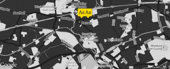
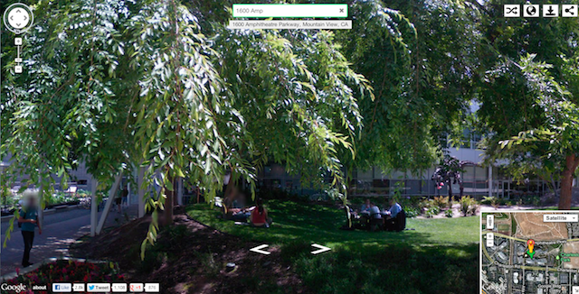
Incorporate a Google map into your app with 3D camera position, markers and infowindows.


Any iOS app can also launch the Google Maps for iPhone app using a 
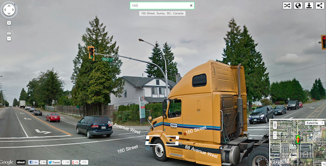
URL scheme. This allows Google Maps for iPhone to be launched to complete a search, show a map or Street View imagery, or to see and navigate walking, driving and transit directions easily.


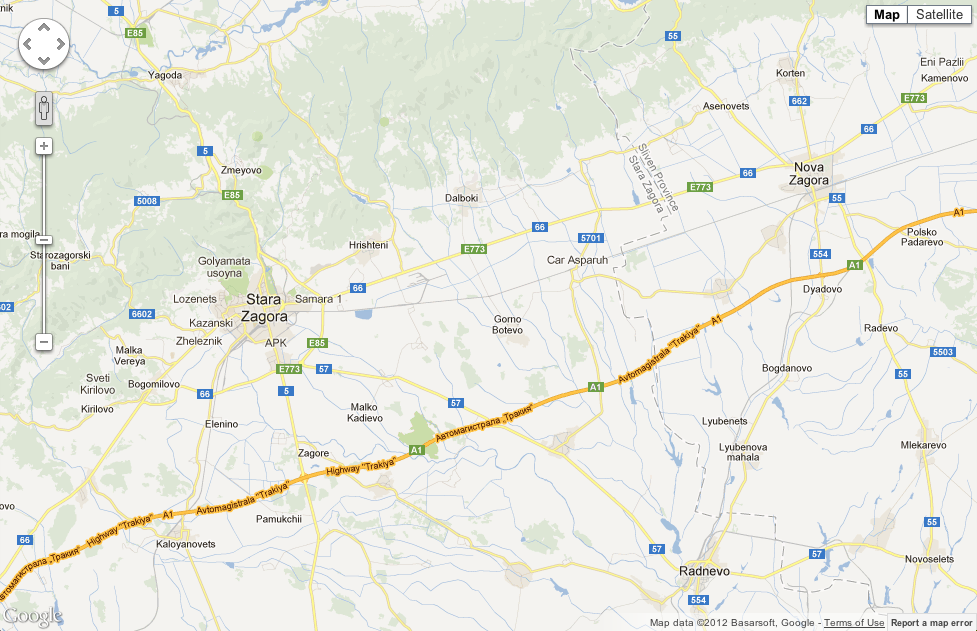
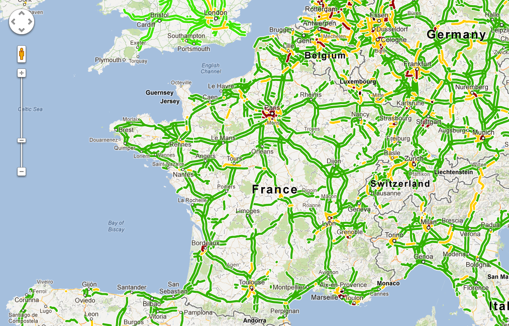
Clicking on the “Directions to here” button in an app shows directions in Google Maps for iPhone, with walking, transit or driving.


Our goal is to provide you with the right tools to build the best mapping experiences across platforms including Android, Web, and now iOS.


To get started, take a look at our SDK documentation, including the URL scheme, and register interest in an API key for embeddable maps in your app.


Map of the Week: London Typographica
Why we like it: London Typographica showcases crowdsourced images of lettering and typefaces around London. It uses Styled Maps to both provide a clean background to display their markers and to allow people to navigate to areas they may want to explore.


Markers drop onto the map using Marker animation, the movement capturing our attention. Clicking on a marker doesn’t open an InfoWindow, but rather brings in a side panel that overlays on top of the left side of the map.


London Typographica is an excellent way for type and lettering enthusiasts to explore London and find their way around, and a great way to use the Google Maps API.

Posted by Mano Marks, Maps Developer Relations


At least I think that’s how the saying goes. Today, we are announcing two new features for the Google Places API that can add some visual pop to your applications: Place Photos and Radar Search.


Place Photos


Photos are one of the most highly requested features from our developers, and we’re confident that the extensive inventory from our Google+ Local pages will suit developers’ local photo needs. To include your own photos in the API, please upload them to the place’s Google+ Page. With Place Photos, each Place Search response will include a reference to a photo, and each Place Details response will include up to 10. The photo fields contain various metadata, as well as a reference that are used to retrieve the photo via the photos service. We also offer a built-in resizing functionality, so your requests can specify the photo’s maximum width and height.


Radar Search


In addition to Place Photos, we wanted to give developers easier access to the comprehensive database underlying the Places API; and what better way to showcase our Place data than by allowing bigger result sets? With Radar Search, you can access up to 200 locations and Place References with one query, no paging needed, giving you more data to play with.


Give this example a try to find the best areas in Sydney for restaurants with nice views, or where to shop for clothes in Paris - this is where the name came from, at a high zoom level, it resembles a radar image. We look forward to seeing even more beautiful visualizations from developers.


The Places API team always appreciates developer feedback so we encourage you to continue requesting additional features, or reporting any problems you find, using the Google Maps API Issue Tracker. Our Stack Overflow community is also a great resource for any technical questions.


Posted by Khang Tran, Google Places API Engineer


More than 800,000 web sites use the Google Maps API to create compelling location-rich applications, including travel guides, real estate portals, engaging data visualizations, and many more.  To help ensure that the maps behind these applications are best in class, the Google Maps team works constantly to ensure that our geographic data is comprehensive and accurate. As part of this ongoing effort, we’re happy to announce we’ve just released updated maps for 10 countries and regions in Europe: Andorra, Bulgaria, Estonia, Gibraltar, Hungary, Latvia, Lithuania, Slovakia, Slovenia and Spain. These new maps will appear immediately on all Google Maps API sites, with no code changes required.

Today’s update is part of a project called Ground Truth that began in 2008. Through this initiative, we acquire high-quality map data from authoritative sources around the world and then apply a mix of advanced algorithms, supplemental data (including satellite, aerial and Street View imagery), and human input to create a map that corresponds as closely as possible to the real-world facts that you’d find if you were to visit that location.

For example, this update adds a new 70-km section of Bulgaria’s Trakiya motorway, which opened recently to drivers but hasn’t been reflected on most maps of the region until now.


In addition to updating our map data, we’ve also enabled the “Report a problem” tool in the API for each of the 40+ countries where this tool is available on the consumer version of Google Maps.  Through this tool, any visitor to a Google Maps API V3 site can now submit corrections and feedback directly to Google, just as they might on maps.google.com.  We review and verify all user feedback and then publish any appropriate corrections -- often within just a few minutes or hours of our review.  The launch of the “Report a problem” tool in the Maps API allows the Google Maps team to increase the accuracy of our maps -- and provide quick and targeted updates to both developers and consumers -- without requiring any work from the owners of sites that use our API.  

We hope these more comprehensive and accurate maps of Europe will enable Google Maps API developers to further enhance their applications (or create entirely new ones) from Barcelona and Budapest to Bratislava and beyond!

Posted by Ken Hoetmer, Google Maps API Product Manager


(Cross posted on Google Maps Lat Long Blog


Today we’re launching an update to the Google Maps Android API, which gives developers the ability to use Google’s comprehensive, accurate and useful maps to build beautiful Android apps. The updated API is easy to use and features vector-based maps that load quickly and enables users to easily navigate 2D and 3D views, and tilt and rotate the map with simple gestures.


With the new version of the Google Maps Android API, developers can utilize Google Maps to its fullest. We’ve incorporated many of the highly-requested features developers want, such as:


  • More dynamic and flexible UI designs for large screen Android devices, such as tablets, using Android Fragments


  • Adding more Google Maps layers in their apps including satellite, hybrid, terrain, traffic and now indoor maps for many major airports and shopping centers


  • The ability to create markers and info windows with less code


Some of our favorite apps already use Google Maps, such as Trulia, Expedia Hotels and FlightTrack. Soon, when you upgrade to the latest version of these apps, you’ll experience the new API and maps as rich as those in Google Maps for Android.


With the latest Google Maps Android API, Trulia Android app users can search for a place to buy or rent in 3D.


To hear from these developers about their apps and migration to the new version of the API, check out the following Google Developers Live video below.


More than 800,000 sites around the world use our mapping APIs to create amazing and useful apps. We hope you enjoy using this new addition to the Google Maps API family and building mapping experiences that were never before possible on a mobile device.


To get started, follow the Google Maps Android API v2 documentation and reach out to the developer community if you have questions on building your app with this API.


Author PhotoIt’s Friday again. Getting ready for the weekend? I know I am. I’m thinking about what mapping project to do over the weekend.


If you’re in the same situation, this video might be helpful. On Wednesday I did another Google Maps Garage. In this one, I walked through some common errors that crop up in Google Maps Apps when loading in JSON objects. I also give out a tip on using Google Earth to gather latitude and longitude for your app.


Regular Fab Friday readers know I am a fan of video game maps. Well, I am also a fan of fantasy maps. And I recently stumbled on this map of the novel Legends of Nuvia: The Soul of Kaesh by Owen Borseth which uses the Google Maps API to show a map of the world of Nuvia.


I like it as a simple example of using a Custom Map Type. In this case, it uses an Image Map Type, and uses tiles created for that purpose.


Posted by Mano Marks, Google Maps Developer Relations team


Map of the Week: Instant Google Street View
Why we like it: Instant Google Street View starts clean, with a simple search box.


As Google, we find this approach very appealing.

As you type, it rapidly updates the page with images from Google Street View...

...until you get where you want to see.


Instant Street View uses the Google Places Library Autocomplete Service to quickly get the location you’re looking for. It uses the Street View Service to display the Street View panoramas. And when you’ve found what you want to look at, you share it via your favorite social media or get a quick map view:


Most of all, we love that it’s fast. So get out there and share some great images from Instant Street View.

Posted by Mano Marks, Maps Developer Relations


Author PhotoYesterday was Thanksgiving in the US. In the spirit of Thanksgiving, I am thankful for the wonderful time with my friends and family. And I am thankful that I get to work with the best group of developers in the world every day. That’s you, Google Maps developer. I truly enjoy working with you. Thank you for giving me the best job in the world.

And to give back a little, I have a video for you! It might be really helpful if you, like many developers, are going to relax and try something new or revive an old project over the weekend.


On Tuesday, Brendan Kenny and I did the first in a series of episodes on Google Developers Live called Google Maps Garage. At the Garage, we get into the nuts and bolts of creating Google Maps applications. In Tuesday’s episode, we focused on common mistakes and road bumps that people run into when making Maps applications, including things like common CSS errors, not setting the sensor parameter in the bootstrap call, and more. Take a look.


Next week, I’m doing it again! There’ll be another Google Maps Garage event next week on Wednesday at 14:00 Pacific. I’ll be diving into some more practical implementation details on using the Google Maps API.

Have a great weekend, and to the US developers out there, Happy Thanksgiving!

Posted by Mano Marks, Google Maps Developer Relations Team


Last month we launched morethanamap.com to showcase the unique features of the Google Maps API. As part of this project, each week we’ve been featuring stories from our global community of developers who are using the Google Maps API to start businesses, help improve their communities or save the environment. We embarked on this journey with a simple thesis: that you could go anywhere any world and find innovative Google Maps API developers doing great things. Last week we ended our journey around the world in São Paulo and we would like to thank all of the developers who were kind enough to share their story with us. That’s why this week, we’re dedicating our “Map of the Week” to the six companies around the world who made this project great.
Map of the Week: #morethanamap Developer Stories Recap


Last month we launched morethanamap.com to showcase the unique features of the Google Maps API. As part of this project, each week we’ve been featuring stories from our global community of developers who are using the Google Maps API to start businesses, help improve their communities or save the environment. We embarked on this journey with a simple thesis: that you could go anywhere any world and find innovative Google Maps API developers doing great things. Last week we ended our journey around the world in São Paulo and we would like to thank all of the developers who were kind enough to share their story with us. That’s why this week, we’re dedicating our “Map of the Week” to the six companies around the world who made this project great.


Moving forward

Now that you’ve had a chance to see how the Google Maps API is being used around the world, we hope that you’ve been inspired to create a Google Maps API powered project of your own. Morethanamap.com is a great place to start to see product demos, but we also have some other great resoruces for developers. Be sure to check our technical documentation at developers.google.com/maps as well as our 3rd party developer showcase at developers.google.com/showcase. You can also engage with the Google Maps API directly on Google+ and StackOverflow.


We’ve also created a short video about what makes morethanamap.com great. In the video below, Luke Mahe, Chris Broadfoot, and Paul Saxman from the Google Maps API Developer Relations team walk us through the technology behind the demos on morethanamap.com.


Before we finish the last entry in the morethanamap blog series, we’d like to thank our featured developers again. We’re proud to share these stories because we recognize that one of the most important parts of the Google Maps API is the community of developers around the world who inspire other developers to do great things.


The Developers

  • Sydney, Australia - We met up with GetFlight founder Ian Cumming. GetFlight is airfare search site based that uses the Google Maps API to help users discover cheap airfare to great destinations.


  • Bangkok, Thailand - Co-founder of Computerlogy, Vachara Aemavat showed us the projects his team has built such as a store locator for Siam Commercial Bank and a viral maps app that helped people find high ground during the Thai flood seasons.


  • Nairobi, Kenya - Mark de Blois and Bernadette Ndege from Upande showed Virtual Kenya which is an online geospatial platform to visualize and share data about Kenya.


  • Hamburg, Germany - Ubilabs, a Google Maps focused development shop, showed us some projects they have built for Germany’s largest brands such as Deutsche Telekom, Blitzer.de, and BMW.


  • Sao Paulo, Brazil - Epungo founders André Tannús and Rodrigo Hanashiro gave us a tour of their real estate startup at their global headquarters (also known as André’s living room).


  • San Paulo, Brazil - We met with Kekanto co-founder, Allan Kajimoto. Kekanto is a popular ratings and recommendations startup based in Sao Paulo that serves all of Latin America.


Below you can view a brief recap of the our journey around the world with Google Maps API developers:


Many thanks again to all the developers for inviting us into their offices, homes, and workspaces and sharing their latest projects with us. Since the start of the Google Maps API, we’ve always been excited to see how people are using maps to make things better and we look forward to the next wave of innovation created by you.


Author PhotoI’m back from Sydney and excited about the upcoming US Thanksgiving Holiday. Of course I’ll probably spend some of the weekend coding and making maps. If you’re like me, I think you’ll enjoy the video I have to share with you as inspiration for your work.

Yesterday, Paul Saxman did a special Maps Developer Live session Mapping with Style, where he discussed how he designed a few of his favorite map styles, and shared a few of his tools and techniques for designing maps for visualizations.


Next Tuesday at 10 am Pacific Time, Brendan Kenny and I will be doing the first installment of Google Maps Garage, where we discuss practical aspects of developing Google Maps applications. In this episode, we will delve into common mistakes people make in developing Maps applications.

Finally, I should note for our French Maps fans that we added France to the Traffic Layer in the Maps API.


To see if traffic is available in your country, you can check our Maps coverage spreadsheet.

Posted by Mano Marks, Maps Developer Relations team


[Editors Note: Last month we launched morethanamap.com to showcase the unique features of the Google Maps API. As part of this project, we’ve been featuring stories from our global community of developers who are using the Google Maps API to start businesses, help improve their communities or save the environment.] ...
Map of the Week: Kekanto


[Editors Note: Last month we launched morethanamap.com to showcase the unique features of the Google Maps API. As part of this project, we’ve been featuring stories from our global community of developers who are using the Google Maps API to start businesses, help improve their communities or save the environment.]


This week we stay in São Paulo, to meet with one of the co-founders of Kekanto. Kekanto is a local search guide created specifically for users in Latin America who want to explore cities, share opinions and meet new people. What’s really exciting about Kekanto is to see a startup that aims to conquer the Spanish and Portuguese speaking markets first, which is made possible due in part to the coverage and language capabilities in Google Maps. We met up with Allan just as the rapidly growing site was moving into a new (a larger office) in São Paulo.


Kekanto was started when the founders realized that US-based local search guides were not really gaining traction with users when exported to Latin America. To make sure that users connected with a product made for them, Kekanto puts an emphasis on hiring managers on the ground that are native residents of their target cities across Latin America. Sharing a successful formula used by other local guides, the site takes a Google Map centric approach to drive activity on the site. The site also uses the Google Places API to provide local search results.


As a whole the design of the Kekanto site is easy to use and it does a great job of integrating the maps where the need to be, without letting them get in the way. We really like are the ability to view public transit layers directly on the map and the ability to calculate directions on the site as well. Another design feature we like is the use of business photos in the custom marker icons. This is really nice way to identify a business and tie the map back to the listings next to the map.


In the video below, Kekanto co-founder Alan Kajimoto gives us a live demonstration of the site.


Many thanks to the Kekanto team for inviting us into their office and sharing their site with us. To learn more about Kekanto and the things that you can do with the Google Maps API, visit morethanamap.com. We end our journey around the world here in São Paulo and we thank all of the great developers who were gracious enough to share with us their story. Next week we’ll recap the journey as well the launch of morethanamap.com, so stay tuned for our final series installment!


Author PhotoI’m at the Google office in Sydney, meeting with Engineers and attending the Geo for Good event. I love being in Sydney, it’s a great city. I got mixed up on the time zones, and realized that I was writing a post on Friday in Sydney but it’ll be published on Friday in California. I should have used the Google Time Zone API. Or, you know, Google Calendar.

This week I have a video for you, and some slides. First the video.

Last Friday, Paul Saxman did a Google Maps Developers Live session, Google Maps Developers Live: Ships, Polylines, Symbols, Oh My!, continuing from the previous session he had done with Brendan Kenny, Visualizing Data with the Google Maps API: A Journey of 245k Points.

Here’s the video:


On Tuesday, I presented at Geo for Good Down Under, a Google Earth Outreach event. My session was New Advanced Features of the Google Maps API, and I posted my slides and links to my demos.

Posted by Mano Marks, Maps Developer Relations Team


[Editors Note: Last month we launched morethanamap.com to showcase the unique features of the Google Maps API. As part of this project, each week we’ll be featuring one story from our global community of developers who are using the Google Maps API to start businesses, help improve their communities or save the environment.] ...
Map of the Week: Epungo


[Editors Note: Last month we launched morethanamap.com to showcase the unique features of the Google Maps API. As part of this project, each week we’ll be featuring one story from our global community of developers who are using the Google Maps API to start businesses, help improve their communities or save the environment.]


This week we cross the equator again, moving from Hamburg to São Paulo, where we meet with the founders of the Brazilian real estate start-up Epungo. Founded by Rodrigo Hanashiro and André Tannús, Epungo is a Google Maps API powered real estate search site that is attempting to make real estate search easy in one of the largest and most complicated cities in the world.


We met up with the founders at their office, which in true start-up fashion, is also André’s living room. In addition to being one of the most innovative Google Maps API sites based in Brazil, what’s really exciting is visiting with two entrepreneurs whose entire focus is on making the best Google Maps based experience for their users.


Epungo was founded when André realized most real estate search sites in Brazil focused on traditional text-based listing. Issues like variable neighborhood definitions, public transit complexities, and high urban density make it nearly impossible to search for real estate using addresses and descriptions alone. The Epungo solution to this problem is to concentrate all the search efforts on a map with a clean, well designed, and easy to use interface. To make search easier users have a several map tools to choose from, such as Drawing Tools functionality, custom colored coded icons, and embedded Street View.


According to the founders, one of the main reasons they chose to develop on the Google Maps API was that the coverage and comprehensiveness of Google’s road data, as well as satellite and Street View imagery in Brazil makes it possible for Epungo to reach markets that would otherwise be impossible.


In the video below, Epungo co-founders Rodrigo Hanashiro and André Tannús give us a live demonstration of their site.


Many thanks to the Epungo team for inviting us into their office (and home) and sharing with us their latest projects. To learn more about Epungo and the things that you can do with the Google Maps API, visit morethanamap.com. Tune in next week to read about our visit with Kekanto.


[Editors Note: Earlier this month we lauched morethanamap.com to showcase the unique features of the Google Maps API. As part of this project, each week we’ll be featuring one story from our global community of developers who are using the Google Maps API to start businesses, help improve their communities or save the environment.] ...
Map of the Week: Ubilabs


[Editors Note: Earlier this month we lauched morethanamap.com to showcase the unique features of the Google Maps API. As part of this project, each week we’ll be featuring one story from our global community of developers who are using the Google Maps API to start businesses, help improve their communities or save the environment.]


This week we move on from Nairobi to Hamburg, where we met with Ubilabs. In the middle of Hamburg’s old town is a rapidly growing workshop of developers, designers, and business people focused on building the next generation of Google Maps powered applications. Their speciality has been used to build applications for Europe’s largest brands such as Deutsche Telekom, Blitzer.de, and BMW. Below are a few examples built by Ubilabs that showcase great design and community action powered by the Google Maps API.


Crowd-sourcing to Fix Real Estate Problems

In a thriving city, real estate comes at a premium and sometimes people take advantage of that scarcity by mislabeling or misusing available real estate. To combat this problem, Ubilabs was called upon to build Leerstandsmelder.de (or the "Vacancy Reporter") in which users exchange information about the activities of a given property on a Google Map. Users can upload address data, photos, and detailed information here. They can also coordinate their search using Google Street View imagery integrated on the site. The result is that users can pool their collective knowledge to document alleged misuses and use this resource to lobby their local government to take action.


Showcasing a Global Brand

When Deutsche Telekom relaunched their corporate website they used Ubilabs and Google Maps to build a showcase of all of their affiliated companies and holdings worldwide. What makes this map great is that it uses several Google Maps API features to create a customized experience to reflect the corporate identity of Deutsche Telekom. Features like Styled Maps are used to match corporate colors, while custom markers, navigation and info windows complete a distinct identity. What's most unique about this map is the use of Google Maps as both the background and the foreground on the page. The map extends across the entire page with navigational menus floating on top of the map. The design flexibility, speed, and responsiveness of the Google Maps API are part what makes a design like this possible.


In the video below, Ubilabs co-founders Martin Kleppe and Michael Pletziger give us a live demonstration of these great projects.


Many thanks to the Ubilabs team for inviting us into their office and sharing with us their latest projects. To learn more about Ubilabs and the things that you can do with the Google Maps API, visit morethanamap.com. Tune in next week to read about our visit with Epungo in São Paulo, Brazil.


In 2011, Google Earth Outreach launched a new program to fund nonprofits that want to create cutting-edge maps for public good. Today, we’re excited to announce the winners of the 2012 Google Earth Outreach Developer Grants program. We’ve selected eight nonprofit organizations, listed below, that have presented a compelling ideas for a new map or mapping technology that will make a positive impact on the world. Each winner received a grant to support the technical development of their map. The winners include:


Organization*
Idea
The Royal Canadian Geographical SocietyA Developing World: a Maps API application containing UN Human Development Index data
Clinton Health Access InitiativeGetting to Zero in Southern Africa: A Temporal and Spatial Map of Malaria Progress
SamSamWater FoundationRainwater Harvesting Tool: Calculate Your Drinking Water using Google Maps
Wild SouthCherokee Trails: Google Earth tours, a map, and an Android app documenting Cherokee Indian geography and the struggle of the Cherokee to remain in their homeland.
InternewsChange of States Map: a Maps API application documenting local impacts and adaptations to climate change in the US.
Vanishing Worlds Foundation / World Oral Literature Project / Language LandscapeLanguage Landscape: an Extensible Model for Mapping Language Dynamics
the Jane Goodall InstituteCommunity-based Forest & Wildlife Monitoring: Scaling Up and Sharing Dynamically Generated Maps
Atlantic Public MediaMonarch Migration: a Google Earth Tour


Work is already in progress on each of the projects, so check back on our Developer Grants page in the coming months to see these maps come to life, and to explore maps created by last year’s grantees.


Watch this video to see an example of a Google Earth Tour made possible by the 2011 Developer Grants program is the Arctic Tern Migration, created by the Atlantic Public Media.


We’re very excited about the organizations that were funded this year, and we wish to thank these hardworking organizations who are improving conditions for people and the planet.


Posted by Tanya Birch, Google Earth Outreach


*These organizations were funded through the Google Inc. Charitable Giving Fund at the Tides Foundation.