Maps Platform
Product updates, customer stories, and tips and tricks on Google Maps Platform
New JavaScript Street View renderer brings rendering improvements and better mobile support
woensdag 17 augustus 2016
Street View is one of Google Maps’ most loved features, providing users with a way to explore and experience the world around them. Developers all over the world use Street View in the Google Maps JavaScript API to make their apps more unique and exciting, giving their users a sense of what it’s like to visit a place in real life.
Today we’re making Street View even better, especially on mobile devices, by launching a new Street View renderer in the Google Maps JavaScript API. Read on for the full details of what we’ve improved!
Better display
Smoother Transitions
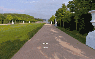
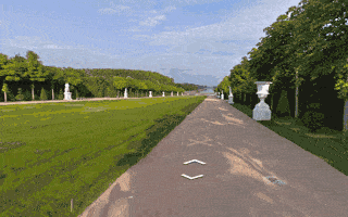
Transitions from one point to another in Street View now include more animation frames, creating the effect of gliding smoothly to the next location. Transitions in the old renderer looked like jumping from one location to another.
Old renderer
New renderer
Smoother Loading Animations
The old renderer repeats images while loading new content, resulting in a stuttering effect. The new renderer uses lower resolution imagery while loading, resulting in a smoother animation when rotating an image in Street View.
Old renderer
New renderer
Object modeling improvements
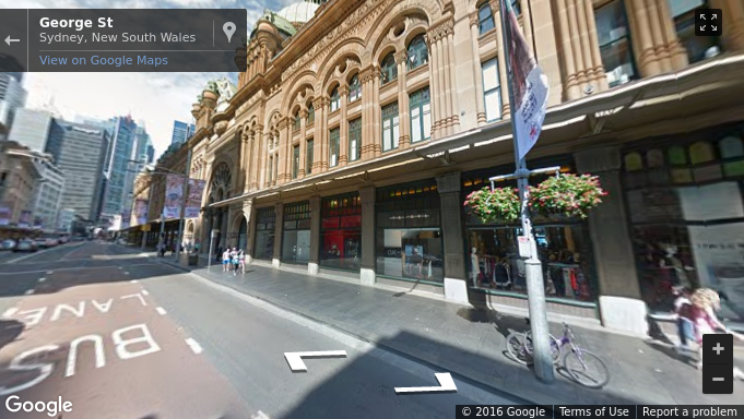
Objects in Street View look better in the new renderer because it builds a 360-degree model that considers all possible perspectives. For example, this high rise building has wavy lines in the old renderer, as opposed to crisp lines in the new renderer.
Old renderer
New renderer
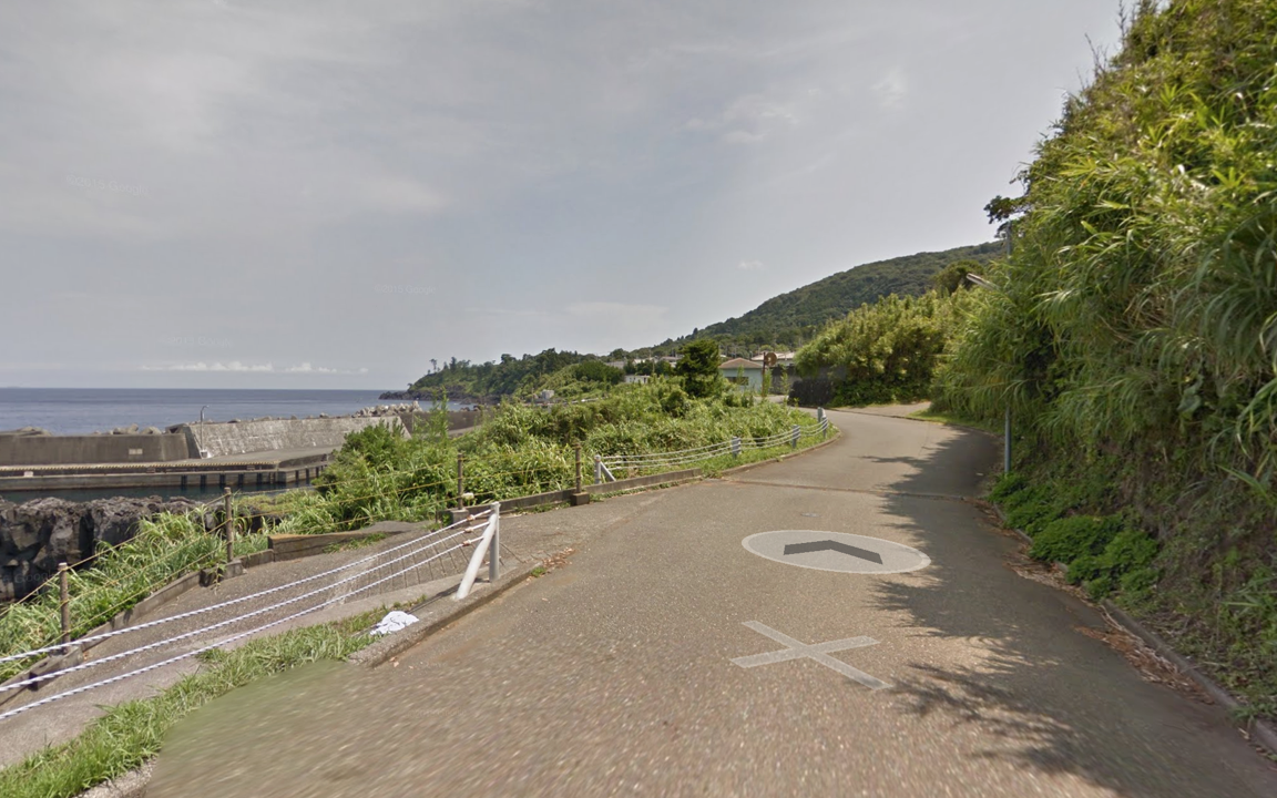
In another example: for imagery on an incline, such as a street with a steep hill, the new renderer corrects the objects to be vertical, whereas the old renderer would have shown the objects at an angle.
Old renderer
New renderer
Better mobile support
WebGL imagery
The new renderer uses WebGL (on
browsers that support it
) which results in a higher frame rate and better rendering, especially on mobile devices. On mobile devices, the old renderer would display a fish-eye projection of the image, whereas WebGL allows us to present a rendered sphere that looks as it would in reality. For example, the street in the image below is straight, but the old renderer made it look curved on mobile devices.
Old renderer
New renderer
Touch support
As mobile web usage grows, users expect familiar touch-based interactions to work everywhere. The new renderer supports the same natural touch-based gestures on mobile which have been available in the Google Maps Android app: pinch-to-zoom and double-tap-to-go. In the old renderer, zooming was only available through the +/- buttons, and movement was only possible by clicking the arrows on the ground.
Motion tracking on mobile devices
Mobile devices give developers the opportunity to provide their users with more natural ways to explore and interact with their applications. We’ve enabled support for device orientation events on Street View so that users on mobile devices can look around in Street View by moving their phone. Developers have the option to turn this off if they prefer. Please see the
developer documentation
for more details, or open the documentation link on a mobile device to see motion tracking in action.
Better controls
X Forward
When using a desktop device with a mouse or trackpad, users will see a small "X" at the cursor location that indicates the next camera location if they choose to move forward. Arrows indicate the direction of movement. Wall rectangles identify the direction the camera will point towards.
Next image targets
Next centered image target
Cleaner street names, labels and targets
Street names and labels are now separated from controls, removing overlap issues and allowing for clean display in right-to-left and left-to-right languages.
Old renderer
New renderer
We hope you enjoy using the new and improved Street View renderer! Also a big thank you to all the developers who use the Google Maps JavaScript API and provide feedback via the
issue tracker
. Getting feedback from developers is vital for us to be able to keep improving our products, so if you have any bug reports or feature requests, please let us know!
For more information on Street View in the Google Maps JavaScript API, please see the
developer documentation
.
Posted by Elena Kelareva, Product Manager, Google Maps APIs
Keep users focused on what's important with the latest Google Maps Android API
maandag 1 augustus 2016
Released today, the latest version of the Google Maps Android API includes more developer requested features: you can now track camera movements more accurately via our new camera listeners, set the minimum & maximum zoom levels on your map, and restrict the user’s panning to particular lat/lng bounds of the camera target. In addition, we’ve added a new marker Tag property so you can now associate your own data object with a marker.
Track camera movements more accurately
As one of our top requests, developers have been asking for a better way to track camera movements and the ability to see why the camera is moving, whether caused by user gestures, built-in API animations or developer controlled movements [
Issue 4636
]. Our new camera change listeners support you in doing this. Your app can now receive notifications for camera start, ongoing, and end events.
See the developer’s guide to
camera change events
and take a look at this
code sample
which shows you how to detect when the user drags the map, and draws a line to track this movement when it happens.
Control the zooming, panning and scrolling experience
Have you ever wanted to be able to control how much your user can zoom in and out and pan around on your map so that you can more tightly control the experience? Or have you got tile overlays only for zoom levels 15 through 20 and wish you could limit the zooming capability of both the map and your tile overlays to those particular levels?
You can now set the min and max zoom levels on your map by using
GoogleMap.setMinZoomPreference()
and
GoogleMap.setMaxZoomPreference()
[
Issue 4663
]. These zoom levels will also apply to any tile overlays you have on your map.
In addition, you can also constrain the lat/lng center bounds of the focal point of the map (the camera target) so that users can only scroll and pan within these bounds using
GoogleMap.setLatLngBoundsForCameraTarget()
. This is awesome if you want your users to stay within the map area of your tile overlays, or you wish to confine the map in your app to a particular local area.
Pan and zoom limits on a map for Adelaide, a beautiful city in South Australia
See the developer’s guide to learn more about
setting boundaries on the map
as well as this
code sample
.
Marker tags
Does your app cater for different types of markers and you want to treat them differently when a user taps on them? Or do you want to assign priorities to your markers? The new marker Tag property allows you to
associate whatever data object you like with a marker
, supporting you in doing this and more [
Issue 4650
].
A big thank you to Android developers everywhere for using the Google Maps Android API and submitting feedback via the
issue tracker
.
Our
release notes
contain details of bugs fixed as well as the features mentioned in this post. Take a look and start using our new features today!
Posted by Megan Boundey, Product Manager, Google Maps Mobile APIs
Labels
5 Great Maps
ads
advertising
africa
Andorra
Android
App Engine
art
Australia
Autocomplete
Boston
brazil
Bruce Springsteen
Bulgaria
Campus Map
Chrome
City 24/7
Code for America
COM API
Computerlogy
creative advertising campaigns
Custom Map Types
design
developer
Developer Challenge
Developer stories
Directions API
Drawing Tools
Driving Directions
Earth
Earth API
Elevation API
environment
epungo
Estonia
Europe
Fab Friday
flash
Fusion Tables
GAE
games
GDAL
Gears
geo
Geodesic Lines
Germany
Gibraltar
GIS
Global Economy
gme
Google Analytics
Google App Engine
Google Earth
Google Earth API
Google I/O
Google Maps
Google Maps API
Google Maps Engine
Google Places API
Google Places API Developer Challenge
Google Street View API
government
Hackathon
Hamburg
heat map
heatmap
hiking
Hungary
iOS
JavaScript
jQuery
kenya
KML
Latitude API
Latvia
launch
Lithuania
local search
London
Mac
Map of the Week
maps
Maps API
Maps API for Flash
Maps Data API
Maps Zen
Marker Clusterer
Marketing
Mars
meetup
mobile
moca
modern art
More Than a Map
Morethanamap
Movies
Neighborhoods
New York City
Office Hours
Olympics
Panoramio
photos
Place Summaries
Places API
Plus
polygons
Premier
public transit
public transit layer
Python
real estate
rock
sao paulo
screencast
SketchUp
Slovakia
Slovenia
South Africa
Spain
Spatial Data Files
Static Maps API
street view
Styled Maps
Sydney
Track
traffic layer
Transportation
Tripline
Twitter
UN
United Nations
V3
Vancouver Olympics
visualizations
Volkswagen
VW
web
youtube
Archive
2018
nov
jul
jun
mei
mrt
feb
2017
nov
jun
mei
apr
mrt
feb
jan
2016
dec
nov
okt
sep
aug
jul
jun
mei
apr
feb
2015
dec
nov
okt
sep
aug
jul
jun
mei
apr
mrt
feb
jan
2014
dec
nov
okt
sep
aug
jul
jun
mei
apr
mrt
feb
2013
dec
nov
okt
sep
aug
jul
jun
mei
apr
mrt
feb
jan
2012
dec
nov
okt
sep
aug
jul
jun
mei
apr
mrt
feb
jan
2011
dec
nov
okt
sep
aug
jul
mei
apr
mrt
feb
jan
2010
dec
nov
okt
sep
aug
jul
jun
mei
apr
mrt
feb
jan
2009
dec
nov
okt
sep
aug
jul
jun
mei
apr
mrt
feb
jan
2008
dec
nov
okt
sep
aug
jul
jun
mei
Feed
Follow @GMapsPlatform
Follow
Google Maps Platform Website
Give us feedback in our
Product Forums
.