Maps Platform
Product updates, customer stories, and tips and tricks on Google Maps Platform
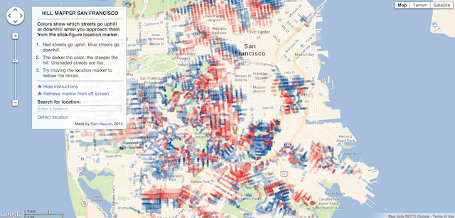
Map of the Week: Hill Mapper San Francisco
woensdag 31 juli 2013
Map of the Week:
Hill Mapper San Francisco
Hill Mapper San Francisco uses the
Elevation API
to show how steep streets are in San Francisco.
Streets that go uphill, relative to the current location of the marker, are red, and downhill streets are blue. The opacity of the color represents how steep the hill is.
If you drag around the marker, the
Polylines
change color, as the marker’s elevation changes the relative elevation of the streets.
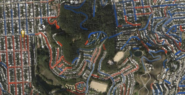
It’s particularly powerful if you view it with satellite imagery.
If you want to search for a particular location, the search box uses
Places Autocomplete
to help you find it.
All around, this is a nice, innovative use of our APIs to show off useful information.
Posted by
Mano Marks
, Maps Developer Relations Team
Fab Friday is on the Street Again
vrijdag 26 juli 2013
Hey y’all, it’s Friday again, and Fab Friday is back with a great new video.
It’s high summer in the Northern Hemisphere and you’re going to want to go outdoors. Specifically, on the street. As we
announced last week
, with the latest version of the
Google Maps SDK for iOS
you can now include Street View in your app. Brett Morgan from the Maps Developer Relations team produced a Maps Shortcuts episode on this new feature, showing you how easy it is to start. Check it out:
That’s all for this week, see you next week!
Posted by
Mano Marks
, Maps Developer Relations Team
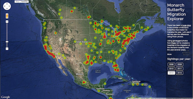
Map of the Week: Monarch Butterfly Migration Explorer
donderdag 25 juli 2013
Map of the Week:
Monarch Butterfly Migration Explorer
Why we like it:
This is a classic mashup style map, using the
Google Maps JavaScript API
with the
Flickr API
to create
HeatmapLayers
of photos tagged as
Monarch Butterflies
.
You can see in the 2012 migration season there were many pictures taken of the Monarchs all over and many of them made it up to Canada. And in 2013 that number dropped off considerably,
possibly due to the increased use of pesticides
.
The map defaults to a satellite
map type
, but if you click on “Map” it changes to our roadmap map type. You can see the map uses the
Google Maps visual refresh
.
We really like how this map uses these two APIs to discover and display trends that neither of the APIs were designed to do. We also like the great use of Google Maps for data visualization, and hope we see more from this developer.
Posted by
Mano Marks
, Maps Developer Relations Team
Fab Friday is Summering
vrijdag 19 juli 2013
It’s been a while since we posted a Fab Friday post. Naturally, with it being summer and all, I was a little distracted. But it’s not summer in Sydney, and they’ve been busy! You may have seen that we launched
Dynamic Maps Engine Layers
in the
JavaScript Maps API
a couple weeks ago.
Josh Livni
hosted a Maps Live episode on it: Visualizing Maps Engine Data on JavaScript Maps. Check it out:
This week we
launched
version 1.4 of the
Google Maps SDK for iOS
. It includes cool new features like Street View, indoor maps, and an updated map style. Check out this Maps Live episode
Luke Mahe
and I did.
It’s shaping up to be a great summer in the Northern Hemisphere! Thanks Sydney!
Posted by
Mano Marks
, Maps Developer Relations Team
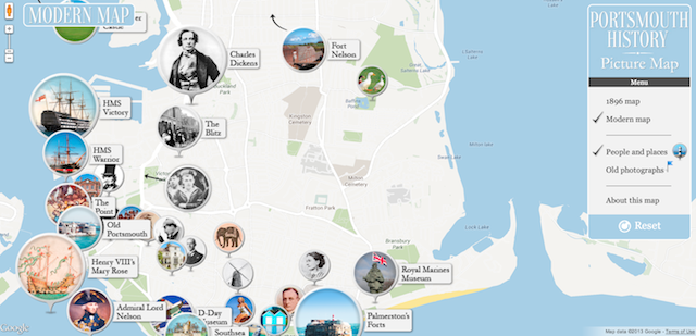
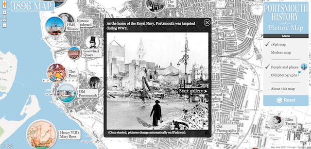
Map of the Week: Portsmouth History Photo Map
donderdag 18 juli 2013
Map of the Week:
Portsmouth History Photo Map
Why we like it:
The Portsmouth History Photo Map is a great demonstration of combining old maps and photos with Google Maps.
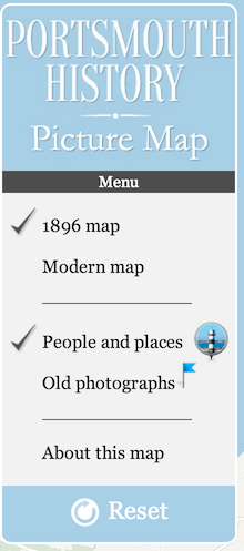
You start by viewing the 1896 map of Portsmouth on top of a Google Map. The old map is overlayed on top of the Google Map using an
ImageMapType
.
You can choose to look at standard Google Maps base map by clicking on Modern map, which reverts you to the road map.
The featured markers, such as this one for Charles Dickens, are created using a standard
Marker
with a custom
icon
and size.
Instead of the standard
InfoWindow
, the developer created a
Custom Overlay
that allows for a more dynamic experience, allowing for a gallery of photos to be displayed in the overlay.
Finally, to control what’s showing on the map, the developer created a custom div that sits on top of the map and controls it with onclick events.
All in all a great custom implementation of our API.
Posted by
Mano Marks
, Maps Developer Relations Team
Street View, indoor maps, and an updated map design in the Google Maps SDK for iOS
dinsdag 16 juli 2013
Since the launch of the
Google Maps SDK for iOS
last December, we’ve brought over a dozen of the most requested features to the platform and today, alongside the update to the Google Maps for iOS app, we’re announcing v1.4 of the SDK.
Download the SDK
to add an immersive mapping experience to your app, powered by accurate data from Google Maps.
With this update, developers can write a few lines of code to access popular features of Google Maps including: Street View in 50 countries, more than one billion square feet of indoor floor plans, and an updated design of our map tiles. For an overview of the new features in this release, watch this introduction from Google Maps Developer Relations team,
Mano Marks
and
Luke Mahe
:
Street View
Why drive 5 million miles of roads when you can use a few lines of code to bring Street View to your app? Use Street View panoramas to give users additional visual cues about a location. Try embedding Street View alongside a map or business photos to give your app real-world context. Or find inspiration in some our creative Javascript Street View implementations:
GeoGuessr
,
Driveway Decision Maker
, and
Converse Street Ready
.
Indoor Floor Plans
Indoor floor plans let you bring your users one level deeper by giving them access to floor plans inside shopping malls, airports, train stations and more. In a store finder, imagine showing users the inside of the building where your store is located, rather than just street level.
Updated Map Design
One point of feedback that we’ve heard consistently is that you want a map that blends seamlessly with your app UI. This version of the Google Maps SDK for iOS includes an update to the map tiles, that draws design inspiration from the new Google Maps. We’ve removed the yellow roads, which gives the map a more neutral palette, so that your app’s colors, styles, and map markers can stand out.
The updated map design (right) is inspired by the new Google Maps and has a more neutral palette, so that your app UI can shine.
We’re continuing to iterate rapidly to add features that you want. Let us know what you’d like to see in the next release of the Google Maps SDK for iOS using the
issue tracker
, and if you have questions, post them to the Google Maps API
Developer Community
.
Posted by
Daniel Schramm
, Associate Product Manager, Google Maps.
Labels
5 Great Maps
ads
advertising
africa
Andorra
Android
App Engine
art
Australia
Autocomplete
Boston
brazil
Bruce Springsteen
Bulgaria
Campus Map
Chrome
City 24/7
Code for America
COM API
Computerlogy
creative advertising campaigns
Custom Map Types
design
developer
Developer Challenge
Developer stories
Directions API
Drawing Tools
Driving Directions
Earth
Earth API
Elevation API
environment
epungo
Estonia
Europe
Fab Friday
flash
Fusion Tables
GAE
games
GDAL
Gears
geo
Geodesic Lines
Germany
Gibraltar
GIS
Global Economy
gme
Google Analytics
Google App Engine
Google Earth
Google Earth API
Google I/O
Google Maps
Google Maps API
Google Maps Engine
Google Places API
Google Places API Developer Challenge
Google Street View API
government
Hackathon
Hamburg
heat map
heatmap
hiking
Hungary
iOS
JavaScript
jQuery
kenya
KML
Latitude API
Latvia
launch
Lithuania
local search
London
Mac
Map of the Week
maps
Maps API
Maps API for Flash
Maps Data API
Maps Zen
Marker Clusterer
Marketing
Mars
meetup
mobile
moca
modern art
More Than a Map
Morethanamap
Movies
Neighborhoods
New York City
Office Hours
Olympics
Panoramio
photos
Place Summaries
Places API
Plus
polygons
Premier
public transit
public transit layer
Python
real estate
rock
sao paulo
screencast
SketchUp
Slovakia
Slovenia
South Africa
Spain
Spatial Data Files
Static Maps API
street view
Styled Maps
Sydney
Track
traffic layer
Transportation
Tripline
Twitter
UN
United Nations
V3
Vancouver Olympics
visualizations
Volkswagen
VW
web
youtube
Archive
2018
nov
jul
jun
mei
mrt
feb
2017
nov
jun
mei
apr
mrt
feb
jan
2016
dec
nov
okt
sep
aug
jul
jun
mei
apr
feb
2015
dec
nov
okt
sep
aug
jul
jun
mei
apr
mrt
feb
jan
2014
dec
nov
okt
sep
aug
jul
jun
mei
apr
mrt
feb
2013
dec
nov
okt
sep
aug
jul
jun
mei
apr
mrt
feb
jan
2012
dec
nov
okt
sep
aug
jul
jun
mei
apr
mrt
feb
jan
2011
dec
nov
okt
sep
aug
jul
mei
apr
mrt
feb
jan
2010
dec
nov
okt
sep
aug
jul
jun
mei
apr
mrt
feb
jan
2009
dec
nov
okt
sep
aug
jul
jun
mei
apr
mrt
feb
jan
2008
dec
nov
okt
sep
aug
jul
jun
mei
Feed
Follow @GMapsPlatform
Follow
Google Maps Platform Website
Give us feedback in our
Product Forums
.