Maps Platform
Product updates, customer stories, and tips and tricks on Google Maps Platform
Map Tips: Using the Google Maps APIs to book the perfect ride
donderdag 13 augustus 2015
Posted by Richard Coombes, Google Maps Solutions Architect at Google
Editor’s note: ‘Map Tips’ are designed to answer frequently asked questions about
Google Maps APIs
. For important tips on how to deploy Google’s mapping tools, read more from
Richard Coombes
, Google Maps Solutions Architect at Google.
The number of transportation booking apps—taxi, rideshare, shuttle and limo to name a few, has exploded over the last few years primarily due to the increase in GPS enabled smartphones, fast and reliable mobile connectivity and simple, secure payment options. These apps offer real benefits to customers, drivers and taxi booking companies and location plays a critical role for all of them. Google Maps APIs enable many feature-rich capabilities that can provide the best location-based information and user experiences for booking and tracking the perfect ride.
Here are eight helpful tips for optimizing your taxi or rideshare services with the Google Maps APIs:
1. Use Places API Autocomplete for easy address entry.
The type-ahead-search suggestions available with Places API Autocomplete makes it fast and easy for the customer to provide an accurate pick-up and drop-off location with minimal keystrokes. The Autocomplete feature is available in
Android
,
iOS
,
Javascript
and as a
web service
for flexible integration options.
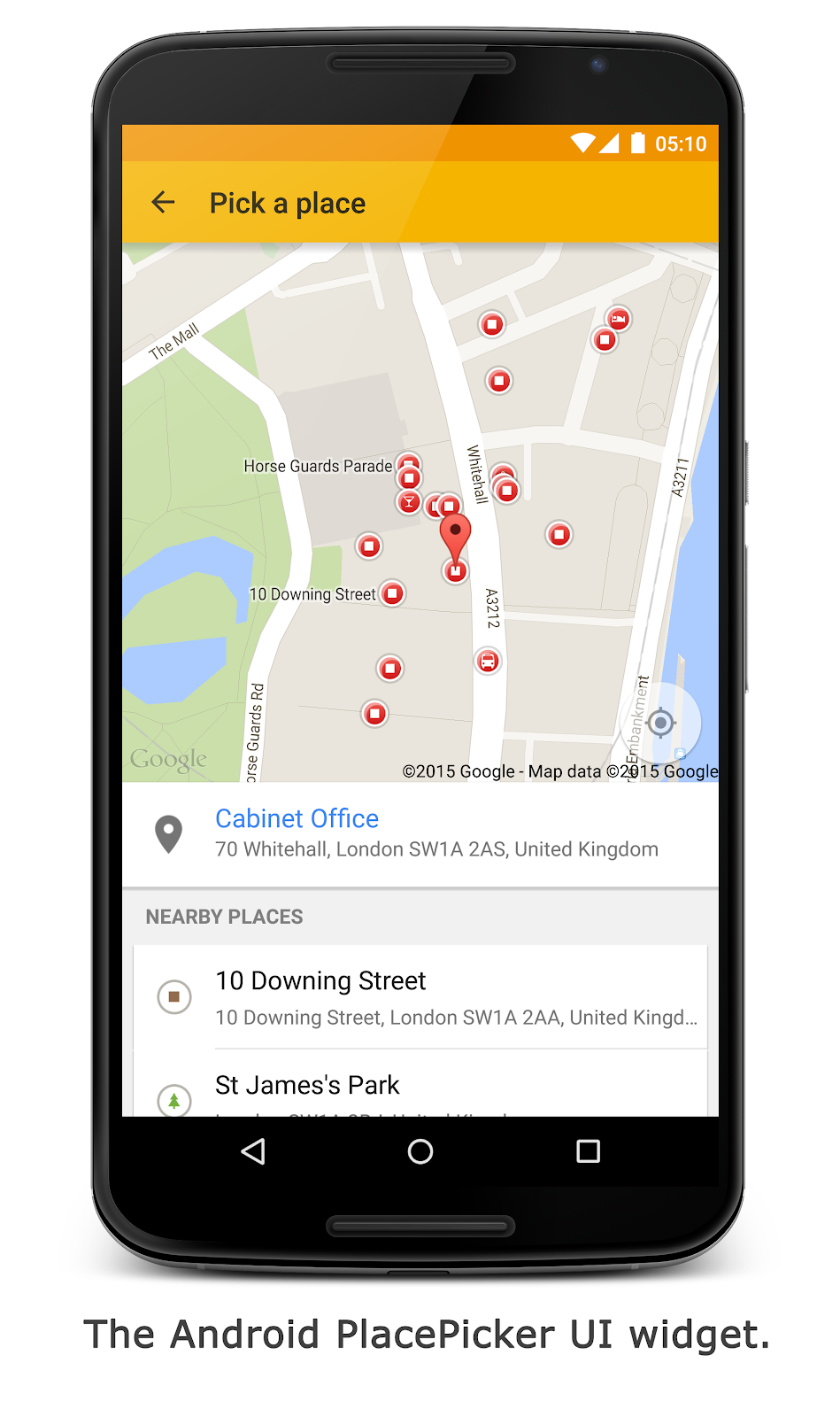
2. Automatically locate the customer for fast booking.
If booking a taxi immediately, allow your customer to automatically communicate their current location using the location capabilities of their smartphone or browser. On Android and iOS make use of the
Places API Place Picker
UI widget so your customer can choose their location from a list of nearby places. Alternatively, the
Geocoding API
can provide the nearest address to their current location.
3. Use the Distance Matrix API to find the closest taxis based on drive time and drive distance.
Performing a simple radius or “straight line” distance search to find the nearest available taxis can often provide misleading results. For example, a taxi may be on the far side of a highway or the other side of a river and take a long time to drive to the pick-up point. The
Distance Matrix API
can calculate the driving distances and times, based on Google’s road network, to improve the accuracy of your search results.
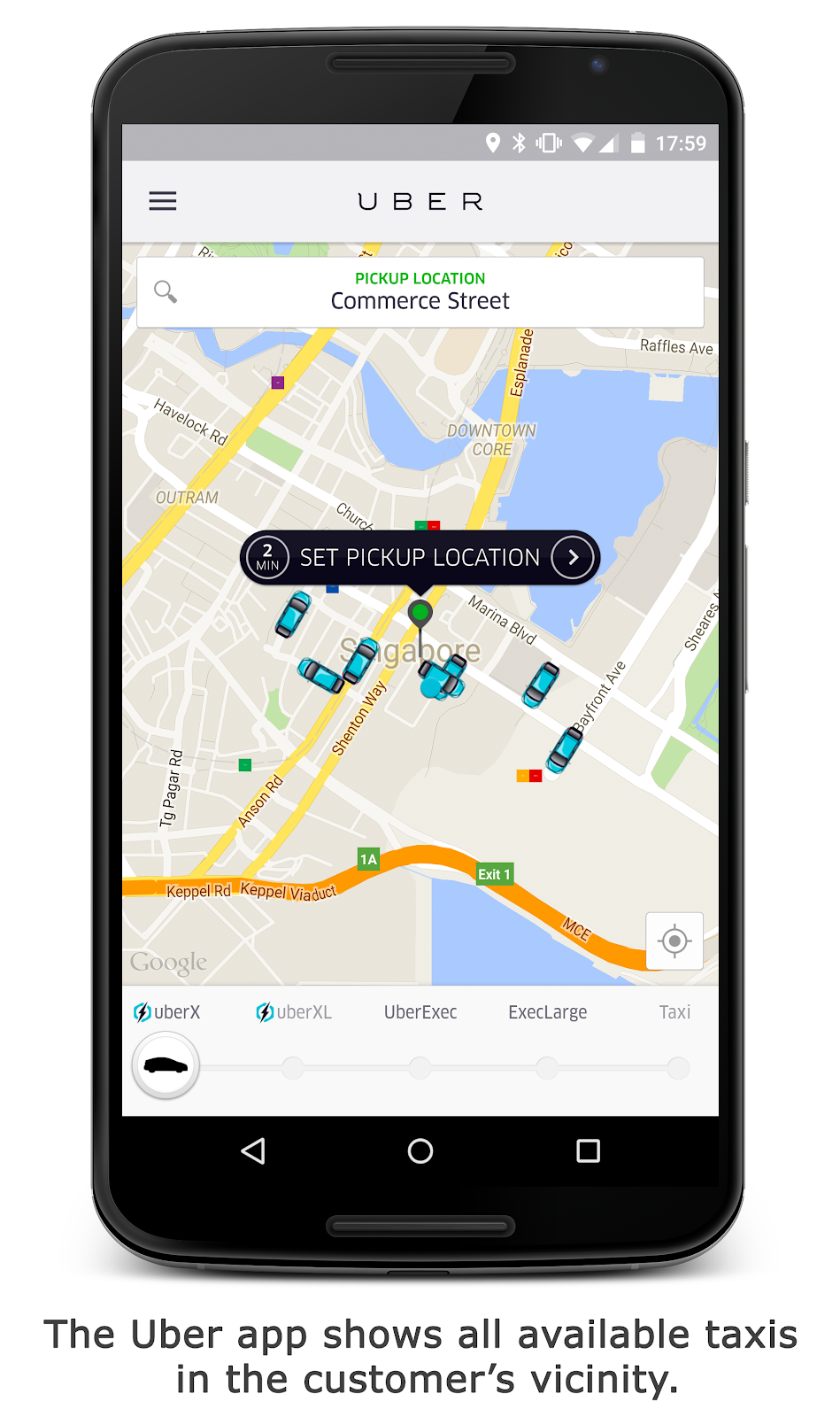
4. Show the real-time location of the customer and driver on a Google Map.
Help reassure the customer that their ride is on the way by showing real-time location of the vehicle on a map—in relation to their position. If the driver is unfamiliar with the area this can also help guide her to the customer’s location. Google has global coverage so if you’re working in multiple countries we’ve got you covered. No need to work with multiple map providers. Asset tracking with Google Maps allows a taxi booking company to view the real-time location and status of all their taxis on a central map to help process offline bookings coming in via telephone calls. Need help storing and retrieving all of your taxi fleet locations? Take a look at our
previous blog post
on how to store your location data in the cloud with Firebase.
5. Provide the customer arrival times based on current traffic conditions.
If your customer is in a hurry, it can feel really frustrating wondering when her taxi will arrive. Keep the customer informed of the vehicle’s estimated time of arrival using the duration-in-traffic information in the
Directions API
.
6. Provide an estimated fare and drop-off time to the customer.
Before the journey starts, provide customers with an estimated fare based on the optimal route and traffic conditions. The
Directions API
can provide the route distance and duration in current traffic. Alternative routes can also be provided. These details can be used to estimate when the customer may arrive at their destination and how much it should cost.
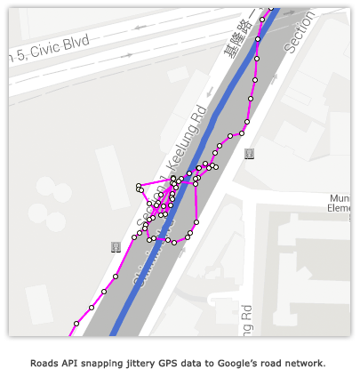
7. Improve measurement accuracy of distance travelled using Roads API.
If you’ve used GPS on a smartphone before you probably know that the accuracy can sometimes be poor, especially in highrise urban environments. If you need to calculate fares, driver payments, fuel consumption or maintenance planning then accurate distance reporting is vital. The
Roads API
can take your original jittery GPS data and snap them to the road network as well as fill in gaps (interpolate) in missing your GPS data to ensure the path smoothly follows the road. This leads to improved distance measurements and better visualisations of where the taxi has actually travelled.
8. Better understand vehicle speed and safety.
Oftentimes a taxi booking company is relying solely on information coming from the driver’s and customer’s smartphone and no in-car telematic devices are available. The Roads API can provide the posted speed limit along a road. This speed limit can be compared with the calculated actual speed of the vehicle (from GPS data) to determine if and where speeding occurs.
We hope you’re able to incorporate some of these ideas into your taxi booking systems. Learn more about what
Google Maps APIs
can do for your websites and applications.
Labels
5 Great Maps
ads
advertising
africa
Andorra
Android
App Engine
art
Australia
Autocomplete
Boston
brazil
Bruce Springsteen
Bulgaria
Campus Map
Chrome
City 24/7
Code for America
COM API
Computerlogy
creative advertising campaigns
Custom Map Types
design
developer
Developer Challenge
Developer stories
Directions API
Drawing Tools
Driving Directions
Earth
Earth API
Elevation API
environment
epungo
Estonia
Europe
Fab Friday
flash
Fusion Tables
GAE
games
GDAL
Gears
geo
Geodesic Lines
Germany
Gibraltar
GIS
Global Economy
gme
Google Analytics
Google App Engine
Google Earth
Google Earth API
Google I/O
Google Maps
Google Maps API
Google Maps Engine
Google Places API
Google Places API Developer Challenge
Google Street View API
government
Hackathon
Hamburg
heat map
heatmap
hiking
Hungary
iOS
JavaScript
jQuery
kenya
KML
Latitude API
Latvia
launch
Lithuania
local search
London
Mac
Map of the Week
maps
Maps API
Maps API for Flash
Maps Data API
Maps Zen
Marker Clusterer
Marketing
Mars
meetup
mobile
moca
modern art
More Than a Map
Morethanamap
Movies
Neighborhoods
New York City
Office Hours
Olympics
Panoramio
photos
Place Summaries
Places API
Plus
polygons
Premier
public transit
public transit layer
Python
real estate
rock
sao paulo
screencast
SketchUp
Slovakia
Slovenia
South Africa
Spain
Spatial Data Files
Static Maps API
street view
Styled Maps
Sydney
Track
traffic layer
Transportation
Tripline
Twitter
UN
United Nations
V3
Vancouver Olympics
visualizations
Volkswagen
VW
web
youtube
Archive
2018
nov
jul
jun
mei
mrt
feb
2017
nov
jun
mei
apr
mrt
feb
jan
2016
dec
nov
okt
sep
aug
jul
jun
mei
apr
feb
2015
dec
nov
okt
sep
aug
jul
jun
mei
apr
mrt
feb
jan
2014
dec
nov
okt
sep
aug
jul
jun
mei
apr
mrt
feb
2013
dec
nov
okt
sep
aug
jul
jun
mei
apr
mrt
feb
jan
2012
dec
nov
okt
sep
aug
jul
jun
mei
apr
mrt
feb
jan
2011
dec
nov
okt
sep
aug
jul
mei
apr
mrt
feb
jan
2010
dec
nov
okt
sep
aug
jul
jun
mei
apr
mrt
feb
jan
2009
dec
nov
okt
sep
aug
jul
jun
mei
apr
mrt
feb
jan
2008
dec
nov
okt
sep
aug
jul
jun
mei
Feed
Follow @GMapsPlatform
Follow
Google Maps Platform Website
Give us feedback in our
Product Forums
.